
|
|
|||||||||||||||||||||||||||||||||
Tropospheric
|
||||||||||||||||||||||||||||||||||
|
monitoring |
|
O3
- tropical NO2 - global - central Europe CH2O - global Aerosol - AOD - aerosol index Clouds - cloud info |
|
monitoring |
|
UV
- UV index - UV dose |
|
monitoring |
|
Ozone
- total column - global field - ozone bulletin BrO - global field |
|
Aviation control |
|
Volcanic plume
- SO2 & AAI |
|
|
Sep 2010
Empa OMI NO2 (EOMINO) product for Europe
Building on KNMI's DOMINO product, Empa has developed a new OMI NO2 data set for Europe which uses high temporal and spatial resolution MODIS surface reflectance data taking into account anisotropic surface reflectance (BRDF) effects (Zhou et al. 2010). Further changes include a better treatment of surface elevation (Zhou et al. 2009) and the online computation of box airmass factors with LIDORT instead of using a pre-computed lookup table. Other aspects are identical to the DOMINO product of KNMI (Boersma et al. 2007). These include the tropospheric slant columns, the a priori NO2 profiles from the TM4 model, and the cloud retrieval. Cloud fractions and cloud pressures, however, have been recomputed with the new surface reflectance data. No attempt has been made yet to correct for the striping apparent in the OMI slant columns.
In addition to this new product this website also provides access to GOME, SCIAMACHY and OMI-DOMINO data over the Alpine domain in an easy-to-use gridded ASCII format. For the early years auxiliary information e.g. from trajectory analysis is provided, but these products have been discontinued after 2006.
References:
Data access
Access to regional nitrogen dioxide (NO2) data for the following instruments:
Maps and
ascii data from GOME and SCIAMACHY are provided together with
trajectory analyses and auxiliary
information (e.g., Meteo-wind and cloud fields, lightning,
DOAS measurements) to facilitate user applications.
Product description
Below, a detailed description is given for the following products:- Nitrogen dioxide from satellite for air quality purposes
- Trajectories and source regions
- DOAS measurements and auxiliary information
Nitrogen dioxide from satellite for air quality purposes
NOx is an air pollutant harmful to humans and ecosystems and plays a key role in tropospheric photochemistry as a precursor of ozone and by regulating the abundance of the OH radical. NOx, which is the sum of nitric oxide (NO) and nitrogen dioxide (NO2), is primarily emitted in the form of NO. Oxidation by ozone quickly forms NO2 which is converted back to NO by photolytic decay. A photochemical equilibrium between NO and NO2 is reached within minutes. At some distance from the immediate source, the bulk of planetary boundary layer NOx is constituted of NO2. Good knowledge of the spatial distribution of NO2 is important for assessing the air quality over a given domain. Thereby, not only mean concentrations but also peak loads are relevant and therefore air quality limits have been defined in Europe for both.The satellite NO2 observations used here consist of total tropospheric vertical column amounts. For a proper interpretation of these observations it is important to consider the specific meteorological conditions under which they were sampled.
To simplify access to satellite NO2 observations and to support a user in analyzing and interpreting the data we have established a “Regional NO2 product” restricted to the domain of the Alps and the Po Valley with the following components:
- For each day, a taylored image of the satellite pixels is generated showing the NO2 distribution over the region of interest (Alps and Po Valley)
- The original satellite NO2 data in HDF format is edited to a user-friendly format (ASCII) and aggregated into a regular latitude-longitude grid. Auxiliary meteorological information is addes as well as a quality flag based on the cloud parameters.
- A potential source region is provided for each particular case of observed NO2 based on Lagrangian transport modelling (trajectory calculations).
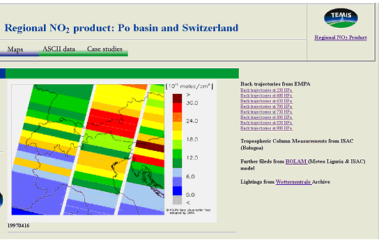
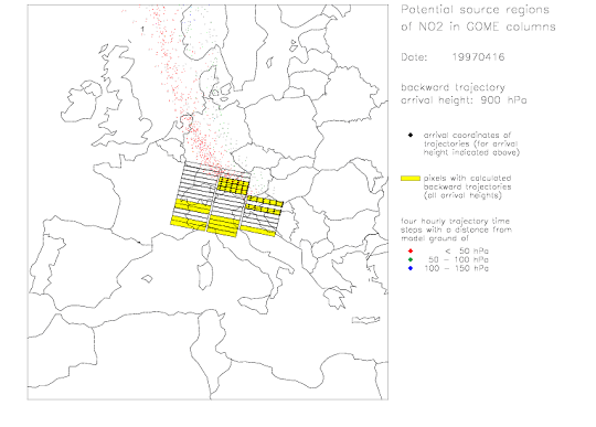
Fig. 1: Example showing the taylored NO2 picture and the assessment of the potential source regions (for air at 900 hPa) for 16 April 1997.
Trajectory calculation and source region visualisation for GOME/SCIAMACHY NO2 columns
For selected satellite pixels (fullfilling certain criteria as specified below) trajectories are calculated backward in from different locations and different altitudes within the pixel. Based on these trajectories, the potential source regions of the observed NO2 is assessed by analyzing the distribution of ground contact experienced by the air masses started from the different sublayers of the satellite column during the previous days.Backward trajectory calculation
Backward trajectories are calculated for every high-quality GOME/SCIAMACHY column in the region of interest (alpine area from 5°E to 14°E and 44°N to 49°N). The columns are defined to be of high quality if one of the following criteria is fulfilled:- The flag “fltrop” in the KNMI data has to indicate a meaningful tropospheric retrieval (fltrop=0; clear sky case), or
- The cloud fraction from FRESCO (“clfrac” in the KNMI data) exceeds a critical value of 0.75 (overcast case).
As the NO2 distribution within the GOME/SCIAMACHY columns is unknown, the backward trajectory arrival points cover the columns both horizontally and vertically to account for the whole tropospheric volume (Tab. 1). In the vertical, 11 height levels between 950 hPa and 450 hPa in 50 hPa steps are used. This vertical resolution allows distinguishing cases where boundary layer air has been transported into the middle troposphere from cases where no such transport has occurred and therefore NO2 remained at low altitudes. Air above 450 hPa is not covered by the trajectory analysis because NO2 at these levels usually only contribute a very small amount to the column. NO2 production by lightning may produce measurable amounts in the upper troposphere, though. To check for this possibility reference to lightning archives such as Wetterzentrale is suggested. Corresponding links are provided along with our data.
Tab. 1: Distribution of the backward trajectory arrival points
in the GOME/SCIAMACHY NO2 columns
| Number of trajectory arrival points |
GOME column |
SCIAMACHY column |
| Across track | 12 | 3 |
| Along track | 3 | 3 |
| In the vertical | 11 | 11 |
| Total | 396 | 99 |
The trajectories are calculated with analysed wind fields with a six
hour temporal and 1° x 1° geographical resolution provided by the
model of the European Centre for Medium-Range Weather Forecast (ECMWF).
Three dimensional kinematic 4-day backward trajectories are calculated with
the software package “Lagranto” (Wernli and Davies, 1997). The arrival time
point is chosen to be on 9:00 UTC in all cases.
Deriving potential source regions
Potential source region maps are derived for each trajectory arrival level. Trajectory positions are plotted in a horizontal projection at 4-hour time intervals. The points are coloured according to their distance from the Earth surface in order to provide a measure for the potential contribution of NO2 sources at each point. Red is used for trajectory points closest to the ground (distance < 50 hPa), green for a distances of 50-100 hPa, and blue for distances of 100-150 hPa. Points with a larger distance from the ground are not shown. As the first arrival height of the trajectories (950 hPa) is almost always located in the planetary boundary layer only the trajectories between 900 hPa and 450 hPa are investigated for their ground contact.
Due to their large size, the trajectory files are not available online but they
can be ordered from EMPA. Only images of potential source regions are provided here.
References
| Webmaster: Dominik Brunner | Introduction | last revision: 27 August 2010 |
|
© Empa / ISAC / TEMIS |